Want to reach up to 5 times more contacts during a disaster?
Sign up for a free trial
Tropical Storm Cristobal forms in Bay of Campeche
ContactRelief is issuing Tropical Weather Strategy alerts for the central Gulf Coast
Tuesday, 02 June 2020 18:14:34 +00:00
As expected, Tropical Depression Three has increased to tropical storm strength forming Tropical Storm Cristobal.
ContactRelief is issuing Tropical Weather Strategy recommendations for U.S. interests along the Gulf of Mexico.
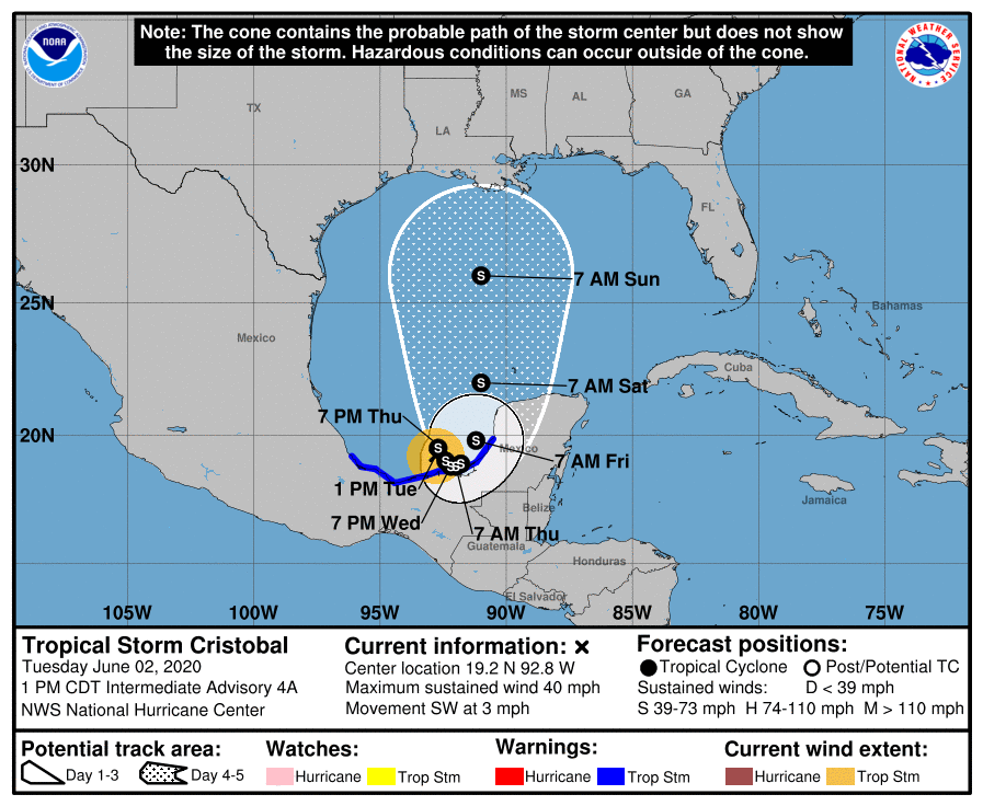
See the public advisory from the National Hurricane Center below.
--------------------------------------------------------------------------------------------------
BULLETIN
Tropical Storm Cristobal Intermediate Advisory Number 4A
NWS National Hurricane Center Miami FL AL032020
100 PM CDT Tue Jun 02 2020
Corrected header to reflect Tropical Storm
...CRISTOBAL MOVING SLOWLY OVER THE BAY OF
CAMPECHE...
...THREAT OF HEAVY RAINS CONTINUES...
SUMMARY OF 100 PM CDT...1800 UTC...INFORMATION
----------------------------------------------
LOCATION...19.2N 92.8W
ABOUT 155 MI...255 KM WSW OF CAMPECHE MEXICO
ABOUT 125 MI...200 KM ENE OF COATZACOALCOS MEXICO
MAXIMUM SUSTAINED WINDS...40 MPH...65 KM/H
PRESENT MOVEMENT...SW OR 220 DEGREES AT 3 MPH...6 KM/H
MINIMUM CENTRAL PRESSURE...1004 MB...29.65 INCHES
WATCHES AND WARNINGS
--------------------
CHANGES WITH THIS ADVISORY:
None.
SUMMARY OF WATCHES AND WARNINGS IN EFFECT:
A Tropical Storm Warning is in effect for...
* Campeche to Puerto de Veracruz
A Tropical Storm Warning means that tropical storm conditions are
expected somewhere within the warning area, in this case within the
next within 24 to 36 hours.
For storm information specific to your area, please monitor
products issued by your national meteorological service.
DISCUSSION AND OUTLOOK
----------------------
At 100 PM CDT (1800 UTC), the center of Tropical Storm Cristobal was
located near latitude 19.2 North, longitude 92.8 West. Cristobal is
moving toward the southwest near 3 mph (6 km/h). The storm is
forecast to move slowly southwestward or southward through tonight,
and meander over the southern Bay of Campeche through late
Wednesday. On the forecast track, the center of Cristobal is
forecast to be near the coast of the southern Bay of Campeche
tonight through Thursday.
Maximum sustained winds are near 40 mph (65 km/h) with higher
gusts. Some strengthening is possible during the next day or so.
The estimated minimum central pressure is 1004 mb (29.65 inches).
HAZARDS AFFECTING LAND
----------------------
Key messages for Cristobal can be found in the
Tropical Cyclone Discussion under AWIPS header MIATCDAT3, WMO
header WTNT43 KNHC, and on the web at
www.hurricanes.gov/text/MIATCDAT3.shtml
RAINFALL: Cristobal is expected to produce total rain accumulations
of 10 to 20 inches with isolated maximum amounts of 25 inches over
parts of the Mexican states of Tabasco, Veracruz, and Campeche. The
depression is also expected to produce total rain accumulations of
10 to 15 inches over northern Chiapas and other Mexican states,
Quintana Roo and Yucatan. Additional rainfall of 10 to 15 inches,
with isolated amounts of 25 inches is expected along the Pacific
coasts of Chiapas, Guatemala, and El Salvador. Some of these Pacific
locations received 20 inches of rain over the weekend, and storm
total amounts of 35 inches are possible. Rainfall in all of these
areas may produce life-threatening flash floods and
mudslides.
WIND: Tropical storm conditions are affecting the coast within
portions of the warning area.
Forecaster Pasch