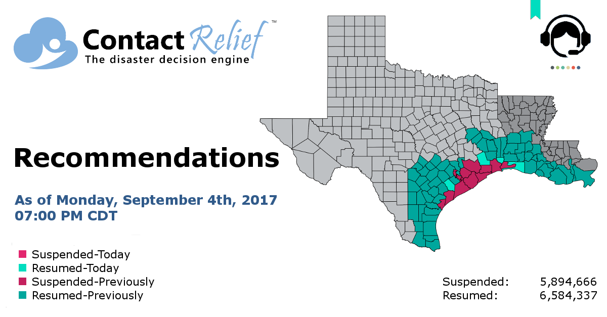
ContactRelief Recommends Resuming Contact for Additional Texas Counties and Louisiana Parishes
ContactRelief recommends resuming contact with consumers in certain Texas counties and Louisiana parishes.
Tuesday, 05 September 2017 07:00:00 -05:00
ContactRelief is making public a recommendation made to subscribers Monday, September 4th, to resume contact with consumers in additional Texas counties and Louisiana parishes while retaining the suspension for certain zip codes.
Contact should be resumed today for these Texas counties: Jackson, Liberty, Orange.
Contact should be resumed today for these Louisiana parishes: Cameron with certain zip codes excluded from this resumption.
A previous recommendation to suspended contact remains in force for Texas counties: Brazoria, Calhoun, Chambers, FortBend, Galveston, Harris, Jefferson, Matagorda.
A previous recommendation to resume contact remains in force for Texas counties: Angelina, Atascosa, Austin, Bastrop, Bee, Bexar, Brooks, Caldwell, Cameron, Colorado, Comal, DeWitt, Duval, Fayette, Gonzales, Guadalupe, Hays, Hidalgo, Houston, JimWells, Karnes, Kenedy, Kleberg, Lavaca, Live Oak, McMullen, Trinity, Waller, Wharton, Willacy, and Wilson. Certain zip codes are excluded.
A previous recommendation to resume contact remains in force for Louisiana parishes: Assumption, Iberia, Jefferson, Lafourche, Plaquemines, St.Martin, St.Mary, Terrebonne.
ContactRelief's On-going Response to Hurricane Harvey
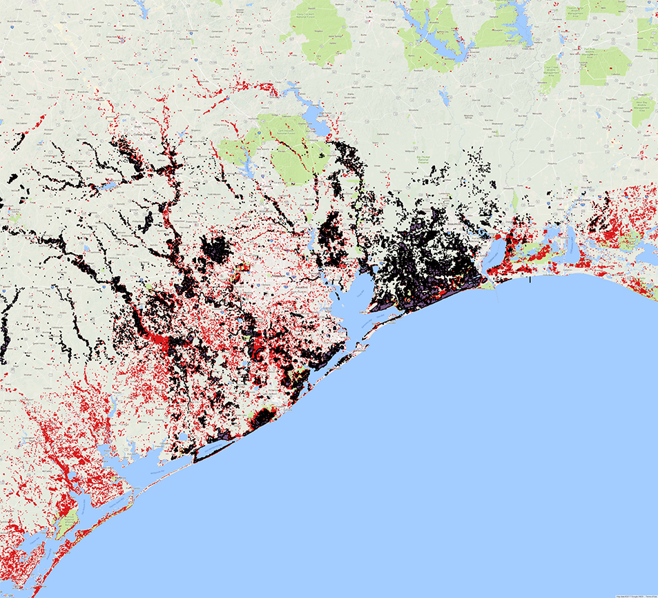
We have begun to identify zip codes that should remain suspended due to the extensive damage in the area. The image below shows the maximum flood extent along the Texas coastline with flood waters shown in white and other areas in black. In addition to localized flooding, you can see the extensive river flooding that has plagued the area since Hurricane Harvey struck.
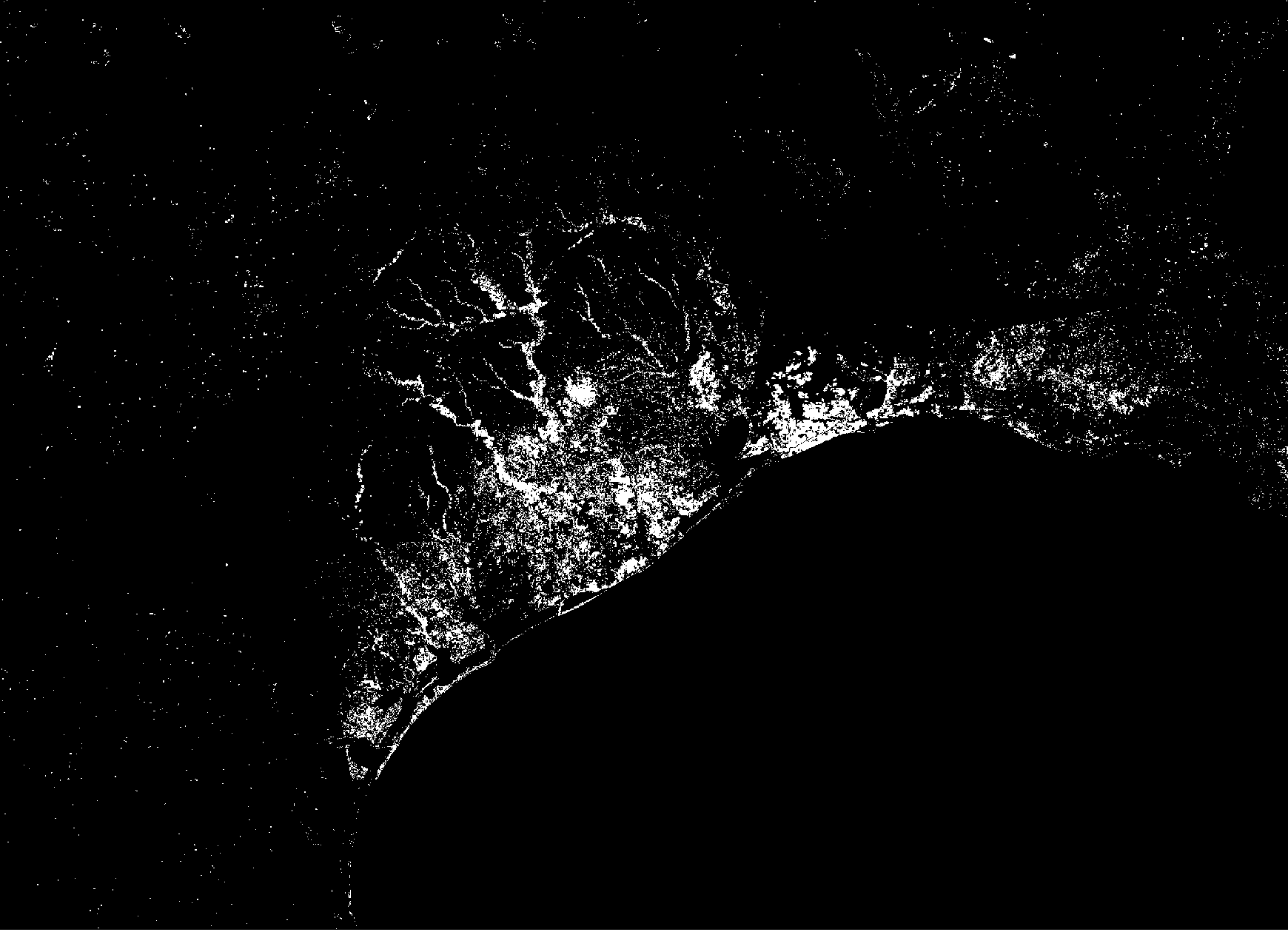
We are using multiple datasets in this process. These images were constructed by comparing before after satellite images of the area. Although they indicate the presence of flood waters, the depth of water is not knowable without additional terrain modeling. We have employed multiple data sets developed using different satellites, shown in the image below in red and in blue, to improve our understanding of the event.
For a limited time, ContactRelief is providing our full recommendations without charge as a service to the business community. Our full recommendations consist of the areas to be suspended and the list of zip codes covering these areas. Contact sales@contactrelief.com for more information.
Images modified by ContactRelief courtesy: Brakenridge, G.R. and Kettner, A. J., 09/02/2017, "DFO Flood Event 4510", Dartmouth Flood Observatory, University of Colorado, Boulder, Colorado, USA, http://floodobservatory.colorado.edu/Events/2017USA4510/2017USA4510.html.
Get in touch
Shaping your outbound contact away from disaster stricken areas isn't just the right thing to do, it's smart business. To learn more about how ContactRelief can help you protect your brand, reduce your risk of adverse actions, and improve your contact center efficiency, click below to contact us.
Contact us