Florida Braces for Category 4 Hurricane Dorian
Dorian expected to intensify from current Category 1 to Category 4 before reaching Florida on Monday. ContactRelief is issuing contact strategy recommendations for risk managers and contact centers.
Thursday, 29 August 2019 18:05:20 +00:00
ContactRelief Recommendations for Florida
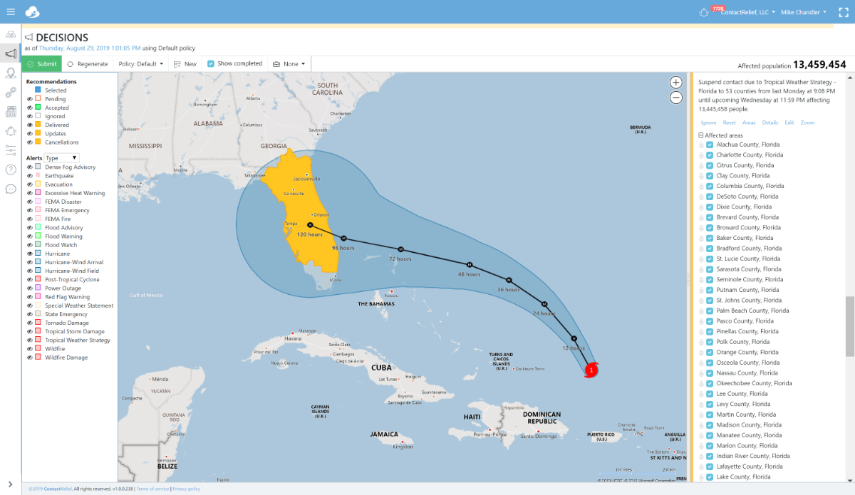
ContactRelief has issued a Tropical Weather Strategy alert and recommendation for parts of Florida through Wednesday 9/4. Our current recommendation is to suspend non-essential contact through close of business Wednesday 9/4. An extension of this recommendation may be required in certain heavily hit areas if the storm makes landfall as predicted.
Dorian is expected to make landfall as a major hurricane on Monday at or near Category 4 strength. Residents are beginning to prepare for the upcoming storm. As the storm nears landfall, these preparations will intensify. You can promote and protect your brand image implementing a proactive customer care policy now. You should consider messaging opportunities before and after the storm, suspension of non-essential contact, financial relief programs or other services, creating specialized IVRs and trained agent groups to handle interaction with disaster victims, and routing calls based on the caller's location.
To obtain a complete list of the affected Zip Codes and get real-time updates on the recovery efforts by Zip Code after the storm hits, become a ContactRelief subscriber.
Tropical Storm Dorian Update
After largely bypassing Puerto Rico, Dorian swept over the Virgin Islands with minimal impact. Dorian reached Category 1 hurricane strength yesterday and is expected to become a major hurricane at Category 3 strength on Friday. The National Hurricane Center predicts Dorian may reach Category 4 strength with winds of 130 MPH before landfall in Florida on Monday.
The National Hurricane Center reports in its Thursday 11 AM AST forecast discussion that the forecast track is still uncertain past day 4 and hence the storm could make landfall to the south or north of the present track.
National Hurricane Center Tropical Storm Dorian Forecast Discussion (Thursday 11AM AST)
Hurricane Dorian Discussion Number 21
NWS National Hurricane Center Miami FL
AL052019 1100 AM AST Thu Aug 29 2019
The small eye of Dorian has appeared intermittently in infrared satellite imagery this morning. Recent reports from a NOAA P-3 aircraft indicate that there is now a double eyewall structure, with a small inner eye only 5 n mi in diameter and a larger 25-n mi diameter outer eyewall. The minimum pressure has fallen to around 986 mb. The concentric eyewall structure is likely why the aircraft has not found any stronger winds yet in the storm, despite the decrease in central pressure. The initial intensity remains 75 kt for this advisory.
Aircraft and satellite fixes show that Dorian is moving northwestward, or 325 degrees at 11 kt. Dorian is forecast to continue moving northwestward during the next 24-36 hours between an upper-level low that will be dropping southwestward across the Florida Straits and a mid-level ridge to the northeast of the hurricane. After that time, a ridge is forecast to build to the north of Dorian, which should cause the track to bend back toward the west-northwest. The track guidance becomes more divergent beyond 72 hours, primarily due to model differences in the strength of the ridge and whether a weakness develops in the ridge late in the period. The new NHC track forecast is virtually unchanged from the previous advisory, and lies very close to the multi-model consensus. It should be noted that the ECMWF, UKMET, and HFIP corrected consensus models remain south of the official forecast. The spread of the deterministic models and the various ensemble guidance is still considerable at days 4 and 5, and it is too soon to specify where along the Florida east coast the greatest impacts could occur.
Environmental conditions consisting of warm waters and low vertical wind shear along the path of the hurricane should allow for at least steady intensification during the next 2 to 3 days. With the small inner core and favorable conditions, rapid strengthening also remains a possibility, although not likely in the very short term given the concentric eyewall structure. The updated NHC intensity forecast calls for Dorian to become a major hurricane on Friday, and shows a slightly higher peak intensity than the previous forecast. The official forecast is at the upper end of the guidance, in best agreement with the HCCA and HWRF models.
Key Messages:
1. The risk of life-threatening storm surge and hurricane-force winds this weekend continues to increase in the northwestern Bahamas, and hurricane watches could be issued there tonight or Friday. Residents should have their hurricane plan in place and listen to advice given by local emergency officials.
2. There is an increasing likelihood of life-threatening storm surge along portions of the Florida east coast late this weekend or early next week, although it is too soon to determine where the highest storm surge will occur. Residents should have their hurricane plan in place, know if they are in a hurricane evacuation zone, and listen to advice given by local emergency officials.
3. The risk of devastating hurricane-force winds along the Florida east coast and peninsula late this weekend and early next week continues to increase, although it is too soon to determine where the strongest winds will occur.
4. Regardless of the exact track of Dorian, heavy rains are expected to occur over portions of the Bahamas, Florida, and elsewhere in the southeastern United States this weekend and into the middle of next week.
FORECAST POSITIONS AND MAX WINDS
INIT 29/1500Z 21.4N 67.2W 75 KT 85 MPH
12H 30/0000Z 22.9N 68.1W 85 KT 100 MPH
24H 30/1200Z 24.5N 69.6W 100 KT 115 MPH
36H 31/0000Z 25.6N 71.4W 105 KT 120 MPH
48H 31/1200Z 26.3N 73.4W 110 KT 125 MPH
72H 01/1200Z 27.0N 76.9W 115 KT 130 MPH
96H 02/1200Z 27.5N 79.8W 115 KT 130 MPH
120H 03/1200Z 28.1N 81.5W 65 KT 75 MPH...INLAND