Hurricane Dorian Now A Category 5 Storm
Dorian packs 180 MPH winds as it approaches the Bahamas.
Sunday, 01 September 2019 14:07:39 +00:00
ContactRelief Recommendations for Florida, Georgia, South Carolina, and North Carolina
ContactRelief has issued a Tropical Weather Strategy alert and recommendation for parts of Florida, Georgia, South Carolina, and North Carolina. Our current recommendation is to suspend non-essential contact. An extension of this recommendation may be required in certain heavily hit areas if the storm makes landfall. In areas with no damage or less damage, contact may be resumed early after the storm passes.
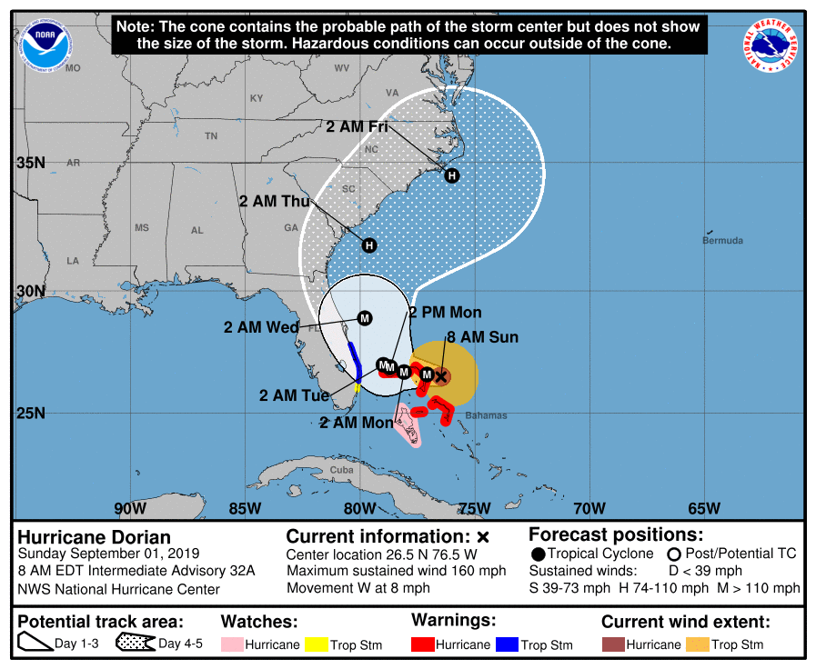
Dorian is a catastrophic hurricane at Category 5 strength. Dorian is expected to approach the Florida coastline on Tuesday. The storm is now predicted to track offshore of the southeastern coastline from Florida to North Carolina. However, the track is still uncertain and as a major hurricane, coastal areas will be severely impacted even if the storm fails to make landfall. We are holding the recommended suspension area constant until the track stabilizes.
Residents are actively preparing for the upcoming storm. As the storm nears landfall, these preparations will intensify further. You can promote and protect your brand image implementing a proactive customer care policy now. You should consider messaging opportunities before and after the storm, suspension of non-essential contact, financial relief programs or other services, creating specialized IVRs and trained agent groups to handle interaction with disaster victims, and routing calls based on the caller's location.
To obtain a complete list of the affected Zip Codes and get real-time updates on the recovery efforts by Zip Code after the storm hits, become a ContactRelief subscriber.
Hurricane Dorian Update
Hurricane Dorian strengthed to a Category 5 hurricane with maximum sustained winds of 180 MPH. As of the 11 AM advisory, the storm was about 20 miles east of the Great Abaco Island. The National Hurricane Center reports that the "eyeball of now catastrophic category 5 Hurricane Dorian is about to hit the Abaco Islands".
Tropical Storm Warnings have been issued for the east coast of Florida.
National Hurricane Center Forecast Discussion
Hurricane Dorian Discussion Number  33
NWS National Hurricane Center Miami FL       AL052019
1100 AM EDT Sun Sep 01 2019

Air Force and NOAA reconnaissance planes penetrated the distinct
eye of Dorian, and found that the hurricane has become extremely
intense with a stadium effect in the eye. The NOAA plane reported a
peak flight-level wind of 159 kt, while the SFMR from both planes
have measured winds between 155 and 170 kt.  A dropsonde from the
NOAA plane measured a wind gust of 176 kt at the surface. A blend of
these measurements yield to an initial intensity of 155 kt, making
Dorian the strongest hurricane on record in the northwestern
Bahamas.

For the next few days, Dorian should experience some fluctuations in
intensity, and in addition to eyewall replacement cyclone, the
interaction with the northwestern Bahamas should weaken the
hurricane slightly. After 3 days, as Dorian moves northward along
or offshore of southeast United States coast, the shear is forecast
to increase, resulting in a more distinct gradual weakening.

Reconnaissance plane and satellite fixes indicate that Dorian, as
anticipated, has slowed down and is moving toward the west or 270
degrees at 6 kt. The steering currents are collapsing and Dorian is
expected to slow down even more, prolonging its catastrophic effects
in the northwestern Bahamas. The NHC forecast calls for a slow west
to west-northwest motion during the next 48 hours, with a turn to
the north and an increase in forward speed as the mid-level trough
along the eastern United States deepens and becomes the dominant
steering feature. The current forecast is only a few miles west of
the previous one and is basically on top of the multi-model
consensus. Both the deterministic and consensus tracks have shown
the usual variability to the right or to the left from run to run,
but the overall trend is for the hurricane to turn northward
offshore but very close to the Florida peninsula.

Given the uncertainty in the track forecast and the anticipated
increase in size of the hurricane, a Hurricane Watch and Storm
Surge Watch have been issued for a portion of the east Florida
coast. It is emphasized that although the official track forecast
does not show landfall, users should not focus on the exact track. A
small deviation to the left of the track could bring the intense
core of the hurricane its dangerous winds closer to or onto the
coast.

Key Messages:

1. A prolonged period of catastrophic winds and storm surge will
affect the Abaco Islands today. Everyone there should take immediate
shelter and not venture into the eye. These catastrophic conditions
are likely on Grand Bahama Island later today or tonight, and
efforts to protect life and property there should be rushed to
completion.

2. Storm surge and hurricane watches and tropical storm warnings are
in effect for portions of the Florida east coast. Life-threatening
storm surge and dangerous hurricane-force winds are possible along
portions of the Florida east coast through mid-week, as only a
slight deviation to the left of the official forecast would bring
the core of Dorian near or over the coast. Residents should listen
to advice given by local emergency officials.

3. There is an increasing likelihood of strong winds and dangerous
storm surge along the coasts of Georgia, South Carolina, and North
Carolina later this week. Residents in these areas should continue
to monitor the progress of Dorian.

4. Heavy rains, capable of producing life-threatening flash floods,
are possible over northern portions of the Bahamas and coastal
sections of the southeast and lower mid-Atlantic regions of the
United States through late this week.

FORECAST POSITIONS AND MAX WINDS

INIT  01/1500Z 26.5N  76.8W  155 KT 180 MPH
 12H  02/0000Z 26.6N  77.7W  150 KT 175 MPH
 24H  02/1200Z 26.8N  78.5W  145 KT 165 MPH
 36H  03/0000Z 27.0N  79.0W  135 KT 155 MPH
 48H  03/1200Z 27.4N  79.4W  120 KT 140 MPH
 72H  04/1200Z 29.7N  80.2W  100 KT 115 MPH
 96H  05/1200Z 32.5N  79.0W   85 KT 100 MPH
120H  06/1200Z 35.5N  74.5W   80 KT  90 MPH
Get in touch
Shaping your outbound contact away from disaster stricken areas isn't just the right thing to do, it's smart business. To learn more about how ContactRelief can help you protect your brand, reduce your risk of adverse actions, and improve your contact center efficiency, click below to contact us.
Contact us