A Hurricane, a Tropical Storm, and a Tropical Depression Walk into a Bar
Three tropical systems will threaten the U.S. next week.
Thursday, 20 August 2020 18:54:15 +00:00
Three tropical weather systems, a Hurricane, A Tropical Storm, and the likely remanents of a Tropical Depression are expected to threaten the U.S. next week.
Tropical Depression 13 Threatens Florida as a Potential Hurricane
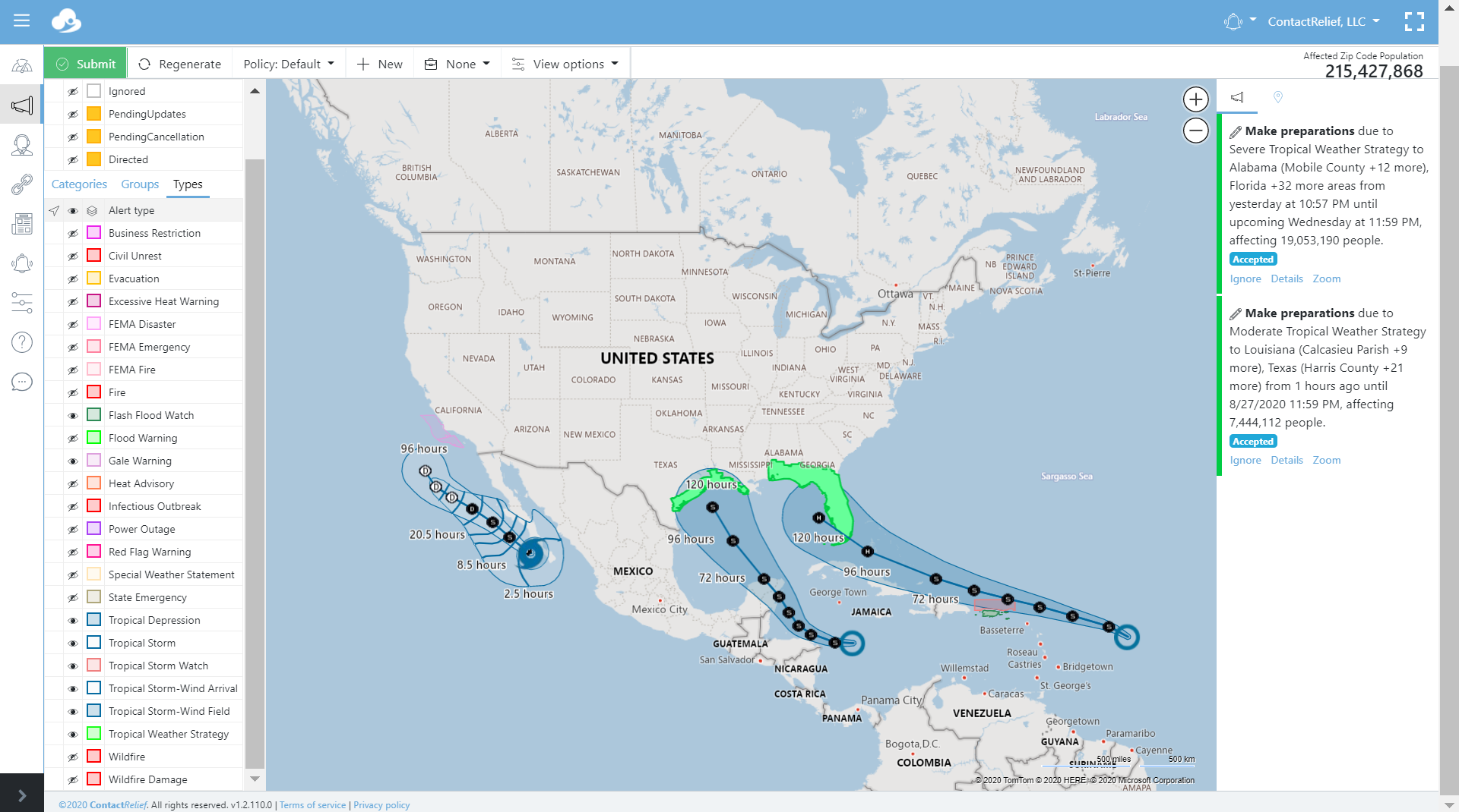
Tropical Depression 13 is forecast to become a Tropical Storm shortly and reach Hurricane strength by Monday (2020/08/24). The current forecast track predicts the storm will cross the Florida peninsula from the Atlantic and travel into the Gulf Mexico before turning northward towards the Florida panhandle.
Key Messages as of 2020-08-20 from the National Hurricane Center for Tropical Depression 13 include:
1. Tropical storm conditions are possible across portions of the northern Leeward Islands by Friday night, and Tropical Storm Watches have been issued for some of these islands. Heavy rainfall is likely across this area beginning late Friday.
2. There is a risk of tropical storm conditions in the Virgin Islands and Puerto Rico Friday night and Saturday and Tropical Storm Watches could be required for these islands later today. Interests there should closely monitor the progress of this system.
3. The details of the long-range track and intensity forecasts are more uncertain than usual since the system could move over portions of the Greater Antilles this weekend. However, this system could bring some storm surge, rainfall and wind impacts to portions of Hispaniola, Cuba, the Bahamas, and Florida this weekend and early next week. Interests there should monitor this system's progress and updates to the forecast over the next few days.
Tropical Depression 14 Threatens Texas and Louisiana as a Potential Tropical Storm (UPDATE: Now expected to also reach Hurricane status before landfall)
Tropical Depression 14 is forecast to reach Tropical Storm strength before impacting somewhere along the Texas or Louisiana coastline. A few long-range unofficial hurricane models show the strorm reaching hurricane strength but most are in line with the official National Hurricane Center prediction of Tropical Storm conditions as the storm approaches the Gulf Coast near Houston next week.
Key Messages as of 2020-08-20 from the National Hurricane Center for Tropical Depression 14 include:
1. Tropical Depression Fourteen is expected to strengthen over the northwestern Caribbean Sea through Saturday, and it could produce tropical-storm-force winds and heavy rainfall over portions of the coast of Honduras and the Bay Islands beginning tonight through Friday. The system could be near or at hurricane strength when it reaches the Yucatan Peninsula of Mexico late Saturday, and watches could be required for a portion of that area later today.
2. The system is expected to move into the south-central Gulf of Mexico as a tropical storm on Sunday. Some strengthening is anticipated while it moves northwestward over the western Gulf of Mexico early next week, but it is too soon to know exactly how strong it will get or the location and magnitude of impacts it will produce along the central or northwestern Gulf Coast. Interests in that area should continue monitoring the progress of this system over the next few days.
Remnants of Tropical Storm Genevieve may bring rain to parts of the Southwest
Hurricane Genevieve recently weaken to Tropical Storm status and further weakening is expected as the storm continues to track west of the Baja Penisula. The storm may bring needed rain to parts of the Southwest. Some long range models show the storm tracking at Tropical Depression strength further up the California coastline before disipating.
Storms tracks may change so stay tuned
We are still 5 days out or more from impacts to the U.S. mainland. The current storm tracks can and likely will change during that time. Companies with interests along the Gulf Coast should pay special attention.
Recommendations for Contact Centers
ContactRelief has issued Tropical Weather Strategy alerts and recommendations for the affected areas. Contact centers should monitor the forecast track, wind field size, and arrival time of tropical force winds in the ContactRelief Command Center and take action if there is any deviation of either storm's forecasted track. Tropical Depression 13 will approach Puerto Rico and the U.S. Virgin Islands in the next few days. Electrical power and other storm impacts are possible in these regions during this time.
The ContactRelief Disaster Decision Team will continue to monitor the storm's development and issue additional advisories as warranted.
Don't Delay
The next disaster is on its way. Become a ContactRelief subscriber and keep your company protected from disaster. Our full recommendations consist of the areas impacted and the associated Zip Codes. For as little as $750 per month your company can quickly implement a solution that protects your company and its customers. As we say at ContactRelief, "It's just smart business."
Contact sales@contactrelief.com for more information.
What can ContactRelief do for you?
Are you ready to see how ContactRelief can shape your disaster operations strategy? Schedule your customized demo to see firsthand how ContactRelief can reduce your workload, protect your brand and improve your contact efficiency.