Hurricane Harvey Reaches Category 2 Strength
The National Huricane Center says Hurricane Harvey, now a category 2 storm, is "dangerously approaching the Texas coast".
Friday, 25 August 2017 07:00:00 -05:00
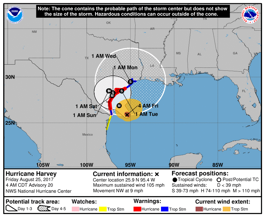
At 4 AM CDT, the National Hurricane Center (NHC) said that Hurricane Harvey is "dangerously approaching the Texas coast" having strengthened to a Category 2 storm. Maxiumum sustained winds of 105 mph where recorded. Harvey is expected to continue to intensify as it approaches the Texas coast.
Hurricane strength is measured using the Saffir-Simpson Hurricane Wind Scale.
| Category | Sustained Winds | Types of Damage Due to Hurricane Winds |
|---|---|---|
| 1 | 74-95 mph | Very dangerous winds will produce some damage: Well-constructed frame homes co uld have damage to roof, shingles, vinyl siding and gutters. Large branches of trees will snap and shallowly rooted trees may be toppled. Extensive damage to power lines and poles likely will result in power outages that could last a few to several days. |
| 2 | 96-110 mph | Extremely dangerous winds will cause extensive damage: Well-constructed frame homes could sustain major roof and siding damage. Many shallowly rooted trees will be snapped or uprooted and block numerous roads. Near-total power loss is expected with outages that could last from several days to weeks. |
| 3 (major) | 111-129 mph | Devastating damage will occur: Well-built framed homes may incur major damage or removal of roof decking and gable ends. Many trees will be snapped or uprooted, blocking numerous roads. Electricity and water will be unavailable for several days to weeks after the storm passes. |
| 4 (major) | Catastrophic damage will occur: Well-built framed homes can sustain severe damage with loss of most of the roof structure and/or some exterior walls. Most trees will be snapped or uprooted and power poles downed. Fallen trees and power poles will isolate residential areas. Power outages will last weeks to possibly months. Most of the area will be uninhabitable for weeks or months. | |
| 5 (major) | 157 mph or higher | Catastrophic damage will occur: A high percentage of framed homes will be destroyed, with total roof failure and wall collapse. Fallen trees and power poles will isolate residential areas. Power outages will last for weeks to possibly months. Most of the area will be uninhabitable for weeks or months. |
The NHC reported that the eye of Hurricane Harvey was located near latitude 25.9 North, longitude 95.4 West. Harvey is moving toward the northwest near 9 mph (15 km/h), and this general motion is expected to continue during the next couple of days. On the forecast track, Harvey will make landfall on the middle Texas coast tonight or early Saturday. Harvey is then likely to meander near or just inland of the middle Texas coast through the weekend.

Harvey is expected to produce total rain accumulations of 15 to 25 inches and isolated maximum amounts of 35 inches over the middle and upper Texas coast through next Wednesday. During the same time period Harvey is expected to produce total rain accumulations of 7 to 15 inches in far south Texas and the Texas Hill Country eastward through central and southwest Louisiana, with accumulations of up to 7 inches extending into other parts of Texas and the lower Mississippi Valley. The NHC says that rainfall from Harvey will cause "devastating and life-threatening flooding".
In addition, the combination of a dangerous storm surge and the tide will cause normally dry areas near the coast to be flooded by rising waters moving inland from the shoreline. The water is expected to reach 12 ft in some areas.
ContactRelief's recommendation to suspend contact with consumers in the affected areas was issued Thursday, August 24 at 10:16 am CDT and continues to remain in effect until further notice.
Protect your brand AND revenue when disaster strikes.
Try ContactRelief FREE for 30 days. Discover how we can help you reach up to 5x more customers in a disaster zone – while protecting your brand image.
Start free trial