Tropical Storm Dorian Expected to Become a Hurricane Within 48 Hours
ContactRelief has issued a Tropical Weather Strategy alert and recommendations for Puerto Rico.
Sunday, 25 August 2019 12:12:04 +00:00
ContactRelief Recommendations
On its current forecast track, the National Hurricane Center reports a 30% chance of tropical-storm-force winds affecting Puerto Rico by late Tuesday or early Wednesday. Subscribers that plan to suspend contact in this event are advised to amplify contact Sunday and Monday in order to avoid the impact of this planned contact suspension.
Interests in Florida should monitor the development of a tropical disturbance off the Atlantic coast of Florida.
Tropical Storm Dorian
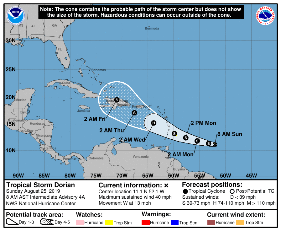
Tropical Storm Dorian Intermediate Advisory Number 4A
NWS National Hurricane Center Miami FL
AL052019 800 AM AST Sun Aug 25 2019
...DORIAN CONTINUES WESTWARD OVER THE WESTERN TROPICAL ATLANTIC...
SUMMARY OF 800 AM AST...1200 UTC...INFORMATION
----------------------------------------------
LOCATION...11.1N 52.1W ABOUT 515 MI...830 KM ESE OF BARBADOS
MAXIMUM SUSTAINED WINDS...40 MPH...65 KM/H
PRESENT MOVEMENT...W OR 280 DEGREES AT 13 MPH...20 KM/H
MINIMUM CENTRAL PRESSURE...1008 MB...29.77 INCHES
WATCHES AND WARNINGS
--------------------
CHANGES WITH THIS ADVISORY:
None.
SUMMARY OF WATCHES AND WARNINGS IN EFFECT:
A Tropical Storm Watch is in effect for... * Barbados
A Tropical Storm Watch means that tropical storm conditions are possible within the watch area, generally within 48 hours.
Additional watches will likely be issued later today for portions of the Windward and Leeward Islands. Elsewhere, interests in Puerto Rico and Hispaniola should monitor the progress of Dorian.
For storm information specific to your area, please monitor products issued by your national meteorological service.
DISCUSSION AND OUTLOOK
----------------------
At 800 AM AST (1200 UTC), the center of Tropical Storm Dorian was located near latitude 11.1 North, longitude 52.1 West. Dorian is moving toward the west near 13 mph (20 km/h), and this motion should continue today, followed by a motion toward the west-northwest on Monday and Tuesday. On the forecast track, Dorian is expected to be near the central Lesser Antilles late Monday or early Tuesday.
Maximum sustained winds remain near 40 mph (65 km/h) with higher gusts. Some strengthening is forecast during the next 48 hours, and Dorian could be near hurricane strength over the eastern Caribbean Sea.
Tropical-storm-force winds extend outward up to 25 miles (35 km) from the center.
The estimated minimum central pressure is 1008 mb (29.77 inches).
HAZARDS AFFECTING LAND
----------------------
RAINFALL: Dorian is expected to produce total rain accumulations of 2 to 4 inches in portions of the Lesser Antilles, with possible isolated maximum amounts of 6 inches.
WIND: Tropical storm conditions are possible within the watch area by late Monday.
SURF: Swells generated by Dorian will be affecting portions of the Lesser Antilles by late Monday. These swells could cause life-threatening surf and rip current conditions. Please consult products from your local weather office.
Tropical Weather Outlook
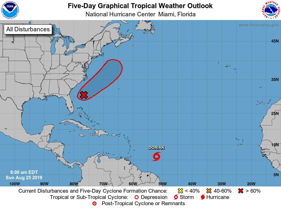
Tropical Weather Outlook
NWS National Hurricane Center Miami FL
800 AM EDT Sun Aug 25 2019
For the North Atlantic...Caribbean Sea and the Gulf of Mexico:
The National Hurricane Center is issuing advisories on Tropical Storm Dorian, located several hundred miles east-southeast of the Lesser Antilles.
1. Showers and thunderstorms remain disorganized in association with a trough of low pressure that extends from the southern Florida peninsula northeastward over the western Atlantic for a few hundred miles. Environmental conditions appear conducive for gradual development, and a tropical or subtropical depression is likely to form within the next few days while the system moves slowly northeastward well offshore of the southeastern United States. Interests along the coasts of South and North Carolina should continue to monitor the progress of this system. An Air Force Reserve Hurricane Hunter aircraft is scheduled to investigate the disturbance this afternoon, if necessary.
Formation chance through 48 hours...medium...60 percent.
Formation chance through 5 days...high...80 percent.
Want to know precisely who NOT to contact during a disaster?
Find out with a free trial