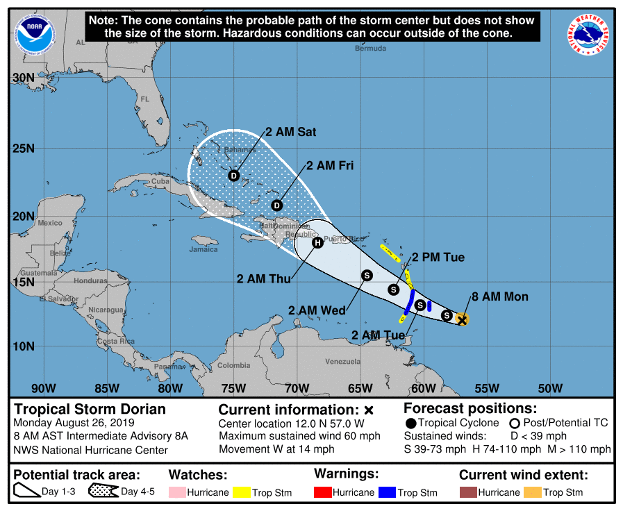
Tropical Storm Dorian Getting Better Organized
Dorian expected to reach hurricane strength by late Wednesday night.
Monday, 26 August 2019 11:55:10 +00:00
ContactRelief Recommendations
On its current forecast track, the National Hurricane Center reports a 30-40% chance of tropical-storm-force winds affecting Puerto Rico by early Wednesday. The Virgin Islands has a 30% chance of tropical force winds.
Subscribers that plan to suspend contact in this event are advised to amplify contact Monday in order to avoid the impact of this planned contact suspension.
Tropical Storm Dorian
Tropical Storm Dorian Intermediate Advisory Number 8A
NWS National Hurricane Center Miami FL
AL052019 800 AM AST Mon Aug 26 2019
...COMPACT DORIAN GETTING BETTER ORGANIZED...
...EXPECTED TO BRING TROPICAL STORM CONDITIONS TO THE WINDWARD ISLANDS LATER TODAY...
SUMMARY OF 800 AM AST...1200 UTC...INFORMATION
----------------------------------------------
LOCATION...12.0N 57.0W ABOUT 205 MI...330 KM ESE OF BARBADOS
ABOUT 315 MI...505 KM ESE OF ST. LUCIA
MAXIMUM SUSTAINED WINDS...60 MPH...95 KM/H
PRESENT MOVEMENT...W OR 280 DEGREES AT 14 MPH...22 KM/H
MINIMUM CENTRAL PRESSURE...1002 MB...29.59 INCHES
WATCHES AND WARNINGS
--------------------
CHANGES WITH THIS ADVISORY:
None.
SUMMARY OF WATCHES AND WARNINGS IN EFFECT:
A Tropical Storm Warning is in effect for...
Barbados
St. Lucia
St. Vincent and the Grenadines
A Tropical Storm Watch is in effect for...
Dominica
Martinique
Grenada and its dependencies
Saba and St. Eustatius
A Tropical Storm Warning means that tropical storm conditions are expected somewhere within the warning area within 36 hours.
A Tropical Storm Watch means that tropical storm conditions are possible within the watch area, generally within 48 hours.
Interests in Puerto Rico, the Virgin Islands, and Hispaniola should monitor the progress of Dorian as watches could be required as early as later today.
For storm information specific to your area, please monitor products issued by your national meteorological service.
DISCUSSION AND OUTLOOK
----------------------
At 800 AM AST (1200 UTC), the center of Tropical Storm Dorian was located near latitude 12.0 North, longitude 57.0 West. Dorian is moving toward the west near 14 mph (22 km/h). A turn toward the west-northwest is expected later today, with this motion continuing through Tuesday night. On the forecast track, the center of Dorian is expected to be near the Windward Islands late today and tonight and move into the eastern Caribbean Sea on Tuesday.
Maximum sustained winds are near 60 mph (95 km/h) with higher gusts. Some strengthening is forecast during the next few days, and Dorian could be near hurricane strength on Tuesday and Wednesday while it moves over the eastern Caribbean Sea.
Dorian is a small tropical cyclone. Tropical-storm-force winds only extend outward up to 45 miles (75 km) from the center.
The estimated minimum central pressure is 1002 mb (29.59 inches).
HAZARDS AFFECTING LAND
----------------------
RAINFALL: Dorian is expected to produce total rain accumulations of 2 to 4 inches in Barbados, the Windward Islands, and Dominica through Tuesday. Isolated maximum amounts of 6 inches are possible in Barbados and the Windward Islands.
WIND: Tropical storm conditions are likely in the warning area by late today. Tropical storm conditions are possible within the watch area by tonight or Tuesday.
SURF: Swells generated by Dorian will be affecting portions of the Lesser Antilles by late today. These swells could cause life- threatening surf and rip current conditions. Please consult products from your local weather office.
