Tropical Storm Harvey Intensifies to Hurricane Strength
Hurricane Harvey is expected to further strengthen on Friday bringing hurricane force winds, flooding, and a life-threatening storm surge to the coast of Texas.
Thursday, 24 August 2017 18:00:00 -05:00
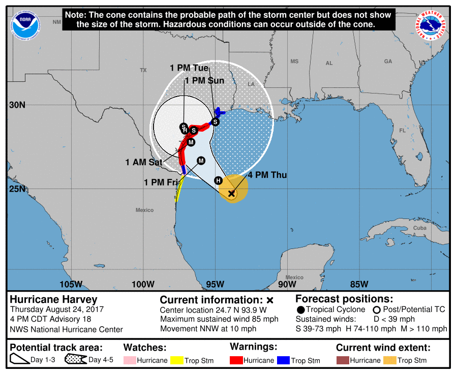
Hurricane Harvey intensified Thursday to hurricane strength as the storm continued to advance on the Texas coastline. The National Hurricane Center said that Harvey is "rapidly intensifying" and is expected to continue to strengthen through Friday becoming a major hurricane.
The NWS has expanded the watches and warning issued since our last update.
- Storm Surge Warnings are in effect from Port Mansfield to High Island Texas.
- Storm Surge Watches are in effect from South of Port Mansfield Texas to the Mouth of the Rio Grande.
- Hurricane Warnings are in effect from Port Mansfield to Sargent Texas.
- Tropical Storm Warnings are in effect from North of Sargent to High Island Texas and from South of Port Mansfield Texas to the Mouth of the Rio Grande
- Hurricane Watches are in effect from South of Port Mansfield Texas to the Mouth of the Rio Grande
- Tropical Storm Watches are in effect from South of the Mouth of the Rio Grande to Boca de Catan Mexico
Harvey is expected to make landfall north of Corpus Christi, Texas.
A Storm Surge Warning means there is a danger of life-threatening inundation, from rising water moving inland from the coastline, during the next 36 hours. The National Hurricane Center says parts of Texas will experience up to a 12-foot storm surge with the deepest water occurring along the immediate coast near and to the northeast of the landfall location, where the surge will be accompanied by large and destructive waves.
In addition to the storm surge, large amounts of rainfall with possible flash flooding are also possible from Brownsville, Texas to New Orleans, Lousiana.
ContactRelief's recommendation to suspend contact with consumers in the affected areas was issued this morning at 10:16 am CDT and continues to remain in effect until further notice. Suspending contact in the impact area allows consumers time to prepare for the approaching hurricane without undue distractions.