
Can We Please Be Done With Hurricane Season?
ContactRelief Consulting Meteorologist Dr. Kevin Levey looks at the state of the Atlantic and examines whether hurricane season is over.
Monday, 25 September 2017 17:00:00 -05:00
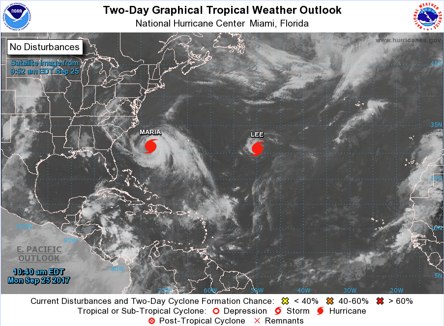
As we enter the last week of September and the start of fall, the Atlantic Ocean appears to be quieting down after an incredibly busy late August and much of September. Hurricane Jose finally weakened and is no longer in the Atlantic, while Maria and Lee are still with us. Figure 1 below, shows the current state as of Monday, September 25th. Currently there are two hurricanes, Maria and Hurricanes Lee.
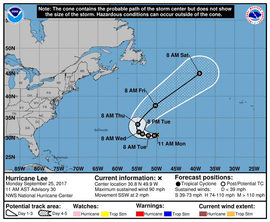
Lee strengthened unexpectedly late last week and as of the 11 AM AST NHC advisory, Hurricane Lee poses no danger to any land areas and is expected to weaken and fade by 8 AM on Saturday as it moves into the northern Atlantic Ocean as seen in the forecast track in Figure 2 below.
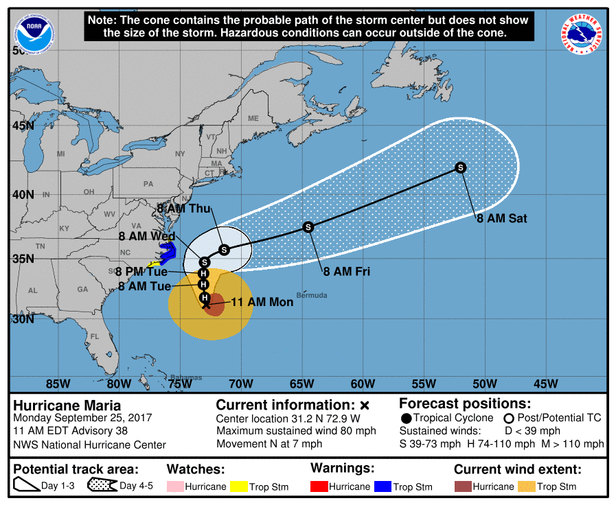
Over the course of the past week, Hurricane Maria made landfall over Puerto Rico as a strong category 4 hurricane with sustained winds of 155mph (category 5 starts at 157 mph sustained maximum winds) and a central pressure of 917 hPa. It was the first category 4 hurricane to make landfall in Puerto Rico since the San Ciprian Hurricane of 1932. Massive destruction of infrastructure was left in Maria’s wake, including leaving nearly the entire island without power. It may be months before power is restored. Thankfully, as seen by the latest advisory issued by the National Hurricane Center shown in Figure 3 below, Hurricane Maria is currently a minimal category 1 hurricane with maximum sustained winds of 80mph moving north at 7mph. It is NOT expected to make landfall over the USA and should move harmlessly out into the northern Atlantic Ocean away from any landmasses. Tropical storm warnings have been issued for much of the Outer Banks as a precaution, with mostly large waves and strong winds anticipated.
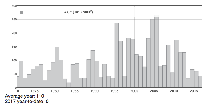
One way to ascertain the strength of a hurricane and a hurricane season as a whole is to look at the Accumulated Cyclone Energy (ACE). It is defined as the square of the wind speed every six hours and is then scaled by a factor of 10,000 for usability. The ACE for a season is the sum of the ACE for each storm and takes into account the number, strength and duration of all tropical cyclones in the season. There is a CAVEAT, however, in that ACE does not take into account the size of the hurricane or tropical storm. Nonetheless, ACE is therefore, both a measure of tropical cyclone activity and a measure of the damage potential of an individual cyclone or a season.
To put ACE into perspective, Figure 4 below, shows the ACE values for the Atlantic Hurricane Season from 1970 through 2016. The average seasonal ACE value is around 110. The ACE through September 2017 has a value of 155.4, which is a new September record breaking the record set back in 2004 with a value of 155. The Atlantic has already generated 40.25 hurricane days in 2017 which is the most for a full Atlantic season since 2005. So, yes, it certainly has been a very active season and it is not over by any means. Don’t forget, the Atlantic hurricane season lasts until November 30th, so we still have more than two full months to go.
In short, while conditions are improving (and that wouldn't be hard given what we seen with Hurricanes Harvey, Irma, Jose, and Maria), it won't be over until it's over. I'm counting the days.