Severe Weather Season
Meteorologist Dr. Kevin Levey examines the hazards of severe weather season.
Sunday, 27 May 2018 04:00:00 -05:00
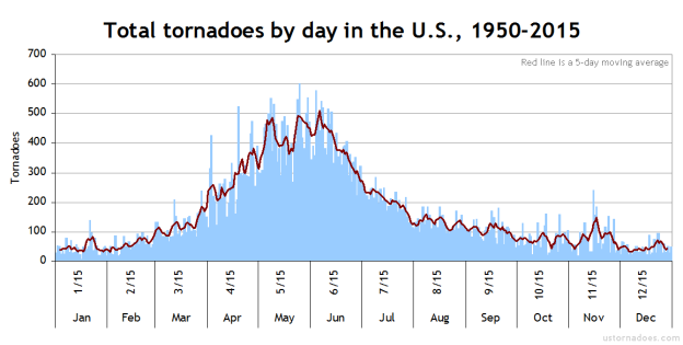
Now that Spring is well underway, and we are well into our annual “severe weather” season over much of the central and eastern parts of the United States. I thought I’d devote this month to all aspects relating to spring severe weather in the United States, including thunderstorms, lightning, hail and of course, tornadoes! Figure 1 below shows the total tornadoes by day between 1950 and 2015, with May 25th as the most active tornado day on average in the United States.
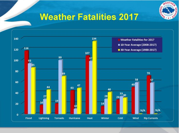
Before I start, let’s look at weather fatalities from 2017. Figure 2 below shows that most people succumbed from weather events that involved flooding, followed by heat and the ocean rip-currents. This varies from year to year, but if you look carefully at Figure 2, you will see that on average (30-year average spanning 1988-2017) 134 people die every year in the USA from heat-related weather events, however, a combined total of 198 people lose their lives every year from flooding (85), lightning (44), and tornadoes (69). Fatalities from flooding include those from severe weather, thunderstorms, snow-melt river flooding and hurricane storm-surge and excessive rainfall. So, even though heat is the silent (passive) killer in the US, deaths from severe weather such as hail, lightning, tornadoes and flooding definitely are the “active” weather killers out there.
For further statistics for individual years, click here:
http://www.nws.noaa.gov/om/hazstats.shtml
Thunderstorms are not rare with over 40,000 of them each and every day around the world. Almost every place on the planet has the potential of experiencing a thunderstorm. The most common weather hazards associated with thunderstorms include:
• Lightning
• Flash Floods
• Hail
• Winds (Downbursts, Microbursts)
• Tornadoes
• Hurricanes
Thunderstorms generally form when warm, humid air rises into an unstable atmosphere. Triggers that initiate uplift include heating of the land surface, frontal lifting (cold fronts cause colder, more dense air to move in under warmer, less dense air and hence cause vigorous uplift in the spring) and also terrain – air being forced up mountain slopes causing mountain thunderstorms which are frequent in the Lake Tahoe area in summer and the Rockies in spring and summer. Another ingredient that enhances strong thunderstorm development is for strong divergent (opposite of convergent, i.e., coming together) winds in the upper levels of the atmosphere. Divergent winds actively “suck” up air from the surface, hence aiding strong vertical uplift within thunderstorms.
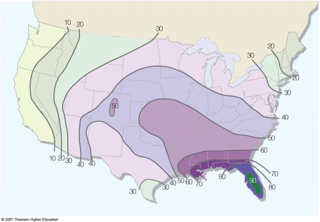
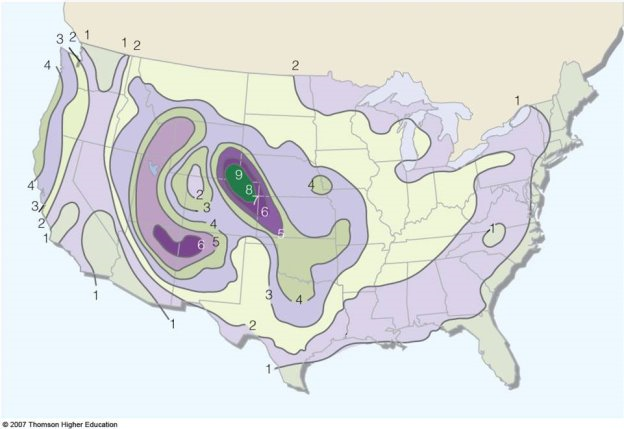
Where do most thunderstorms occur in the United States? Figure 3 below shows the average number of thunderstorms per year in the United States.
Hail frequency does not follow the same spatial distribution as shown in Figure 4 below.
There are essentially three basic thunderstorm types:
• Air-Mass Thunderstorms
• Severe Thunderstorms
• Supercell thunderstorms
Most thunderstorms form with three stages: the cumulus stage (also known as the developing stage) when storm clouds form, the mature stage when the storm is fully formed, and then the dissipating stage when the storm weakens and breaks apart. Figure 1 below shows the three stages.
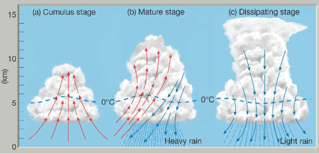
The Cumulus Stage
When warm, moist air moves upward in an updraft, cumulus clouds will form in the atmosphere. The moisture in the air condenses into water droplets as it rises and cools. The cloud will continue to grow as long as warm air from below continues to rise (updrafts). There are several ways that an updraft of warm moist air can form. Sometimes air is forced up the side of a mountain. Air is also forced upward at weather fronts, where warm and cool air masses collide. However, most often than not, updrafts form without a mountain or front to guide them – they form since warm air always rises. Air near the ground heats up during the day as energy from the Sun heats the ground, which then heats the air. The warm air rises higher in the atmosphere since warm air is less dense (lighter) than cool air (which is more dense and heavier). The cloud also extends above the freezing level (0?C/32?F) in the atmosphere.
The Mature Stage
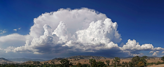
As the cumulus cloud continues to grow, the tiny water droplets within it grow larger too as more water from the rising air is added to the droplets. The cloud starts to look dark and grey as more water is added to it. The droplets that make up the cloud become heavy as they continue to grow. Raindrops start to fall through the cloud when the rising air can no longer hold them up, and gravity pulls the raindrops back to the ground. In the general area where raindrops that are falling out of the cloud, is cool, dry air that also flows downward in the cloud. This air that is cooler and moving towards the ground is called a downdraft and also aids in pulling the raindrops downward. With an updraft, downdraft, and rain, the cloud is now called a cumulonimbus cloud, and the cycling of air up and down is called a thunderstorm cell.
The Dissipating Stage
When the downdrafts in the cloud become stronger than the updraft, the storm starts to weaken. Since warm moist air can no longer rise, cloud droplets can no longer form. The storm dies out with light rain as the cloud disappears from bottom to top. The whole process takes about one hour for an ordinary thunderstorm. Severe thunderstorms like supercells and squall lines are much larger, more powerful, and last for several hours.
Air Mass Thunderstorms.
Air Mass thunderstorms are the most common and least destructive. Their lifespans are generally less than an hour and are very localized. They are also called ordinary, single-cell or garden variety and are not severe in nature, i.e. generally only producing rainfall. They are very common in the spring and summer over much of the central and eastern United States.
Next time we will delve deeper into how severe thunderstorms and supercell thunderstorms (that produce tornadoes) form.
What can ContactRelief do for you?
Are you ready to see how ContactRelief can shape your disaster operations strategy? Schedule your customized demo to see firsthand how ContactRelief can reduce your workload, protect your brand and improve your contact efficiency.