How Tornados Form
Meteorologist Dr. Kevin Levey examines supercell thunderstorms and the formation of tornados.
Wednesday, 30 May 2018 08:00:00 -05:00
Mother Nature does not conform to any schedule, so we take a quick break from our severe weather series to mention Subtropical Storm Alberto, our first named “tropical” system of the season, almost a week early of the official start of the Atlantic Hurricane season. It was not a true “tropical” storm, but had characteristics of both a true tropical storm and subtropical low-pressure characteristics, hence the hybrid “subtropical” nomenclature. As a subtropical storm it did little direct damage, but is still dumping copious amounts of rain across the Southeast raising the potential for localized flooding. Case in point, evacuations were ordered early Wednesday morning below Lake Tahoma Dam in western North Carolina due to concerns about the dam's integrity after torrential rain from Alberto triggered widespread flooding in the southern Appalachians.
Now, let’s compete our final segment of our “severe weather” series. In my last installment, I discussed the various different thunderstorm terminologies and in this last part of this month’s ongoing severe weather blog series, we will look at supercell thunderstorms in more detail and how tornadoes form. Figure 3 below shows a great example of a perfect supercell thunderstorm made up of a single large cumulonimbus cloud and its well-recognized flat anvil at the top.
To recap, supercell thunderstorms:
• are cumulonimbus clouds;
• most dangerous of all thunderstorms;
• Diameter 12 to 30 miles;
• smaller than Squall Line or MCCs (Mesoscale Convective Complexes discussed last week)
• most violent and can produce large hail > 2” in diameter and strong tornadoes.
• life Span: 2 to 4 Hours
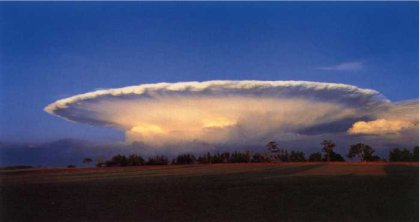
In general, supercell thunderstorms are the only thunderstorms that produce tornadoes and one of the main reasons for this is that these storms are associated with a mesocyclone, or a very large rotating “wall cloud” and updraft as shown below the supercell in Figure 4 below:
However, let’s first look at some of the important ingredients that are needed for typical severe weather outbreaks with their associated supercell thunderstorms and tornadoes.
To summarize here are the most important ingredients critical for supercell thunderstorm and tornado development:
- Strong upper-level winds from the southwest (Jetstream) @ ~ 30,000 feet;
- Cold air from the west the mid-levels (~18,000 feet) to enhance instability;
- Dry air from the southwest in the lower levels (~10,000feet) to enhance instability;
- Warm, moist air from the south in the lowest levels of the atmosphere;
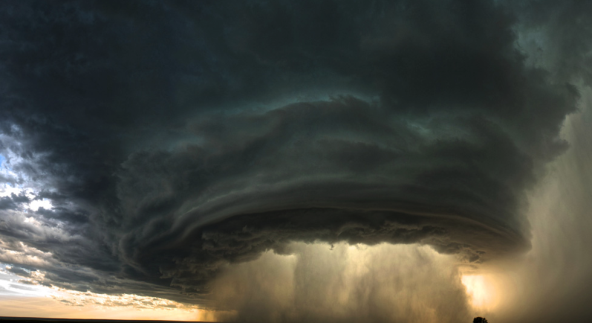
Generally, a cold front moving down from the north with cold air behind it, will move into an area of warmer, moist air from the Gulf of Mexico causing uplift as cold air is more dense than warm, moist air. Uplift causes clouds and if the conditions mentioned above also exist, then explosive development of massive cumulonimbus clouds will occur and ultimately supercell thunderstorms. It just so happens that the atmosphere generally brings all these items necessary for the “severe weather recipe” together in the region known as “Tornado Alley” during spring and early summer as shown below in Figure 5.
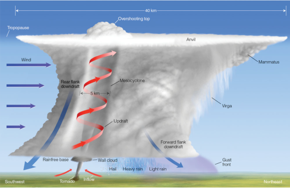
Figure 6 below shows a cross-section of a supercell in detail. You can see that wind increases with height (called wind shear, which is very important for the development of supercells). Generally the winds blow from the west, southwest driving the supercell towards the east or northeast during its lifetime. There is a single large, long-lasting rotating updraft generally associated with a rotating wall cloud at the base of the cloud. There are two areas of descending air known as downdrafts – one is in the rear or flank of the storm and is rain-free, while the downdraft in the leading edge of the supercell is associated with very heavy precipitation, including hail and heavy rain as well as a gust-front that moves out ahead of the cloud. What is very important to note here is that the updraft tilts with height towards the front of the cloud and that the downdrafts or outflow never undercut the updrafts allowing this type of storm to last for many hours.
If a supercell is associated with a tornado, it will be located at the base of the strong rotating updraft and center of the rotating wall cloud.
So, how exactly are tornados formed? First, you must have the supercell already developed and it generally precedes tornado formation by about 30 minutes. As already mentioned, wind shear is caused when wind changes speed with altitude, but it also with direction. Figure 7a below illustrates this point.
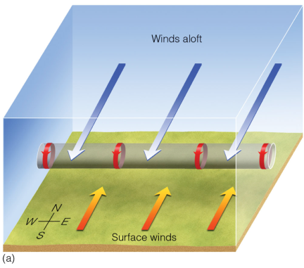
As seen in Figure 7a above, when winds below from different directions as shown, you will observe a rolling motion in the atmosphere or “vortex tube”, but in the horizontal direction (as shown by the red arrows in Figure 7a above). The next logical step is that once you have (a) a supercell with a strong updraft and (b) a horizontal rolling motion in the atmosphere close to each other a tornado results when the strong updraft in the supercell carries the horizonal vortex tube into the thunderstorm producing a rotating air column that is oriented into the vertical plane and this is then known as a tornado. This is seen in Figure 7b below.
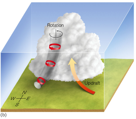
Depending on how strongly the rolling motion was in the horizonal “vortex tube” and how strongly the mesocyclone/wall cloud of the supercell updraft is rotating, will dictate the strength of the tornado.
We’ve run out of time this week, but I will discuss lightning and hail next week.
Are you prepared for the next disaster?
Disasters can strike at a moment’s notice. That’s why, at ContactRelief, we provide round the clock disaster monitoring to keep your operations ahead of disasters. With timely, comprehensive recommendations that are accurate to the ZIP code, ContactRelief ensures you focus less on the disaster, and more on your operations.
Contact sales@contactrelief.com for more information.