Thunder, Lighting, and Hail!
Meteorologist Dr. Kevin Levey winds up his series on severe thunderstorms with thunder, lightening, and hail.
Thursday, 14 June 2018 11:30:00 -05:00
Finally, let’s conclude our severe weather season series talking about hail and lightning.
HAIL
We’ve already discussed the formation of thunderstorms from cumulus clouds building into large cumulonimbus clouds ranging in severity from garden variety afternoon thunderstorms to severe weather supercell thunderstorms.
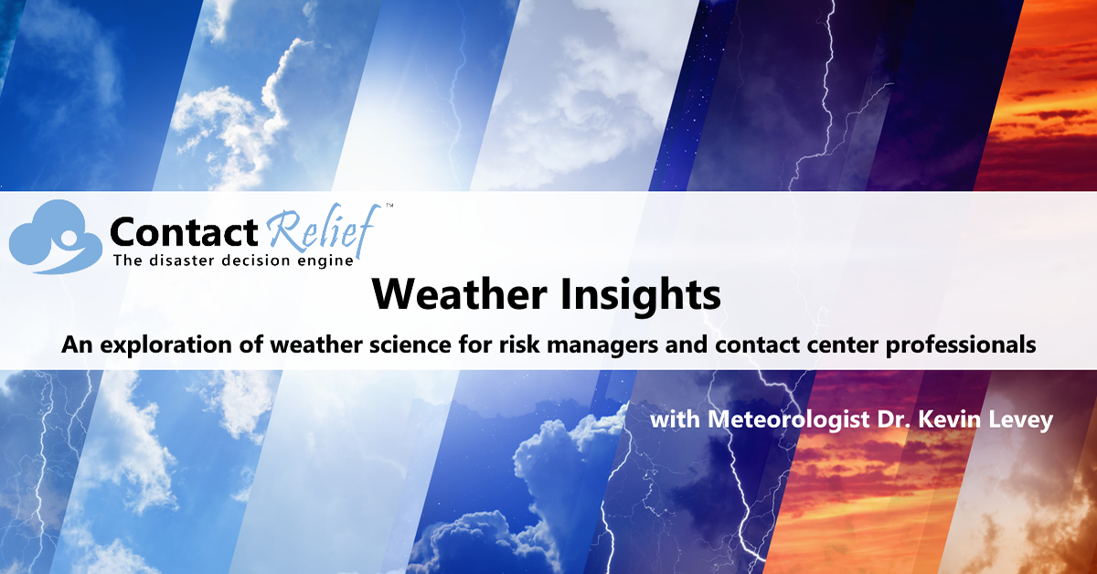
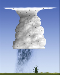
Let’s look at the process of hail formation (refer to Figure 1 for reference)
- Thunderstorms consist of strong updrafts of warm air and downdrafts of cold air.
- If water droplets are picked up by the updrafts they can be carried well above the freezing level. With temperatures below 32?F water droplets will freeze.
- As frozen droplets begin to fall and carried downwards by cold downdrafts. They may thaw as they move into warmer air toward the bottom of the thunderstorm.
- Some hail may fall out of the cloud, however, some may also get picked up again by another updraft carrying it upwards back into very cold air and re-freezing it. With each trip above and below the freezing level the hailstones add another layer of ice.
- Finally, the hailstones consisting of many layers of ice, fall to the ground as they are too heavy to be kept in the cloud by the updrafts – gravity always wins!
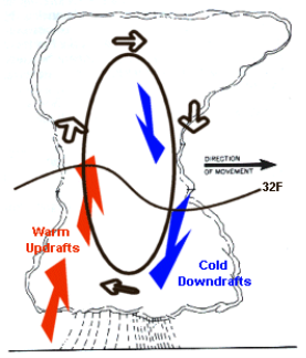
Fortunately, most hailstones are relatively small, generally less than 2” in diameter. The largest hailstone (nearly the size of a volleyball) fell on July 23, 2010 in Vivian, South Dakota and had a diameter of 8.0 inches, a circumference of 18.62 inches, and weighed just under 2 lbs (1 lb and 15 ounces).
THUNDER & LIGHTNING
I discussed hail formation first since without hail and ice crystals in a large cumulonimbus thundercloud, there would be no lightning.
Lightning is essentially a discharge of electricity. The main types of lightning:
- Cloud to ground (~20% of all lightning)
- Cloud to cloud and within cloud (~ 80% of all lightning)
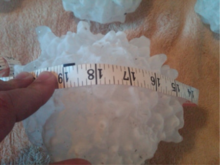
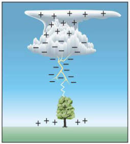
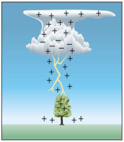
So what causes lightning? Current ice theory states that thunderclouds become differentially charged (See Figure 3 below – right). What does this mean and how does this happen? Simply put, the top of the cloud becomes positively charged and the bottom of the cloud becomes negatively charged. The happens when larger hail stones and tiny ice crystals collide as shown in Figure 4 below (left). The ice crystal becomes positively charge while the hailstone becomes negatively charges after this collision. Since the hailstone is heavier it ends up near the bottom of the cloud, while the lighter and much smaller ice crystals are carried to the top of the cloud by strong updrafts. The more the collision process continues for, the more the top of the cloud becomes more and more positively charged while the bottom of the cloud becomes more and more negatively charged. Eventually a huge difference in charge exists in charges and lightning ensues as the differential is minimized and canceled.
Cloud to ground lightning occurs in a similar fashion. Figure 4 (left) below shows the cloud sending down a negative “leader” or downward lightning stroke (negative current) towards the tree while the tree sends up a positive leader or “return stroke”. Lightning is actually a sequence of downward strokes and return strokes and usually there are at least 2-3 such strokes but there can be up to 20 which occur so fast that it appears to be a single stroke to the naked eye.
Thunder is essentially the explosive expansion of air due to heat from lightning. Below are some characteristics of thunder:
• Air in the lightning column is heated to 50,000?F (The surface of the sun is a mere 6,000?F)
• Heated air expands explosively
• Shockwave causes the loud noise we hear as “thunder”
• Distance -> Time Interval between lightning flash and Sound
• Sounds Travels at 1100 feet per second
• Light Travels at 186, 000 miles per second
• Each 5 seconds between flash and sound is a mile.
• Nearby Thunder Is Sharp
• Distant Thunder Echoes and “Rumbles”
According to NOAA, lightning strikes the United States about 25 million times a year. Although most lightning occurs in the summer, people can be struck at any time of year. Lightning kills an average of 47 people in the United States each year, and hundreds more are severely injured. So, if you see lightning definitely find shelter or go indoors.
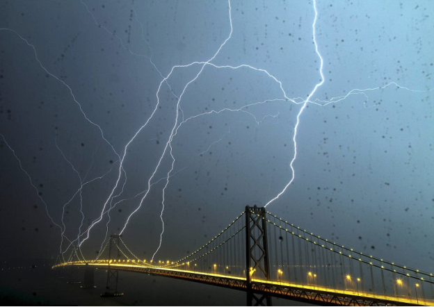
To conclude our severe weather series, I’ve included a once in a lifetime photo of EIGHT lightning strikes on the Bay Bridge in San Francisco (not a place you would usually associated severe weather with) taken on the evening of Friday, 13th April, 2012. Thunderstorms are quite rare in San Francisco, so this was truly a spectacular display of nature’s fury.
Get in touch
Shaping your outbound contact away from disaster stricken areas isn't just the right thing to do, it's smart business. To learn more about how ContactRelief can help you protect your brand, reduce your risk of adverse actions, and improve your contact center efficiency, click below to contact us.
Contact us