
Hurricane Florence Track Accuracy
Meteorologist Dr. Kevin Levey examines the forecast accuracy for Hurricane Florence
Tuesday, 18 September 2018 05:16:00 -05:00
Current Tropical Outlook:
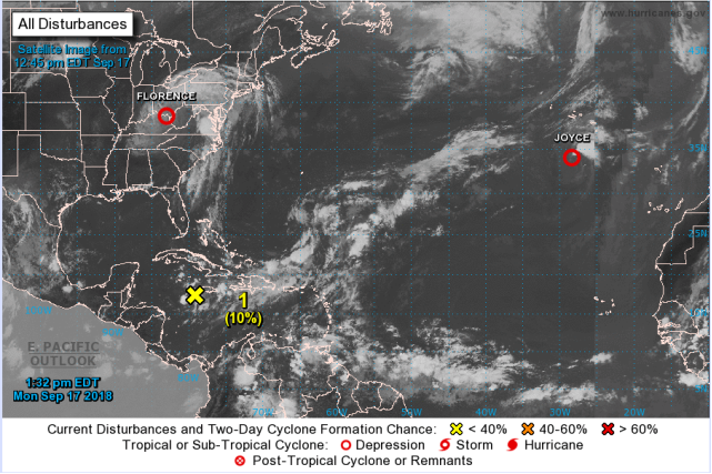
After one of the most active weeks in Atlantic hurricane season history, conditions have finally settled down throughout the basin, with only a weakening Tropical Depression Joyce currently active in the far-northeastern Atlantic (as seen in Figure 1 below). The remnants of Hurricane Florence continue to bring rainfall over a broad area of the eastern U.S. this morning while Gulf Coast is seeing mostly cloud-free skies, which is forecast to remain the case throughout the day today. Looking ahead to the upcoming week, likely the only potential area of interest to the United States will be the remnants of Hurricane Isaac, which are currently located in the central Caribbean Sea. While the remains of this system are currently highly disorganized, this system could become gradually more organized as it drifts slowly westward over the next few days. By Wednesday or Thursday of this week, this system is forecast to progress into the western Gulf of Mexico, where conditions are expected to be more favorable for tropical development. While the chances of this system ultimately developing are low (~20%), interests along the western Gulf Coast will want to monitor the progress of this system.
Florence – National Hurricane Center does an excellent job.
I am starting this account of Hurricane Florence by congratulating the National Hurricane Center on doing an excellent job in predicting landfall. Figure 2 below shows that five days out at 5AM AST on Sunday 9th September, Advisory #40 showed where Hurricane Florence was mostly likely to make landfall ~ somewhere just south of Wilmington, North Carolina.
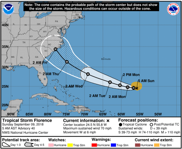
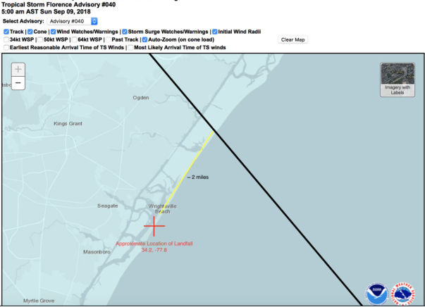
Figure 3 below shows that Hurricane Florence came ashore as a category 2 hurricane only TWO miles from the predicted landfall. This is pretty incredible, that five days out the NHC was able to so accurately predict landfall of Hurricane Florence.
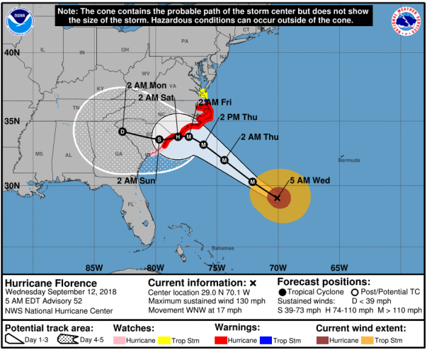
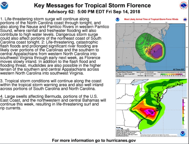
The path and predicted landfall wavered very little and Figure 4 below shows that two days before landfall that the landfall location had changed very little and the intensity had been downgraded to a category 2.
One Wednesday 12th, the NWS was concerned that Florence would stall over the Carolinas after making landfall and made the following rainfall prediction as shown below in Figure 5. Note the >30” predicted totals along the North Carolinas coastline.
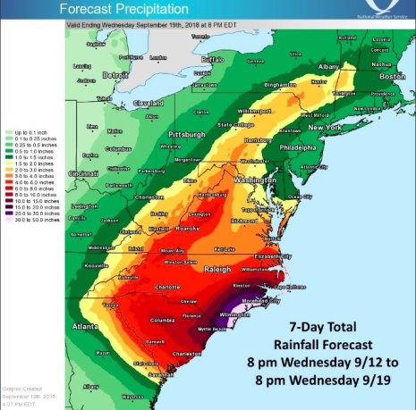
The predicted stalling out over the Carolinas did materialize with Florence hardly moving during the 24 hours after making landfall. Figure 6 below shows that the NWS was extremely concerned about this slow movement which would allow Florence to dump extremely large rainfall quantities over the Carolinas. Over 20” was predicted on top of what had already fallen in the preceding 12 hours.
Figures 7a and b below shows preliminary rainfall totals from Florence in North and South Carolina:
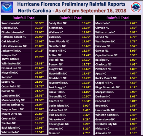
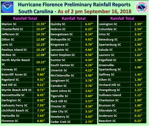
It turns out that Florence set a preliminary highest rainfall total from a tropical system in both North and South Carolina and the predicted rainfall totals did materialize.
As of writing this article, 23 people have lost their lives to Florence, unfortunately, mostly from drowning owing to the massive flooding that is taking place all over the Carolinas as rivers crest. Even though Florence has left the area, it’s effects will still be felt as those trillions of tons of water that fell as rain now heads to the ocean. Thanks to a great effort by the NHC and NWS regional offices and emergency management teams, the loss of life has been kept to a minimum.
Weekly Outlook:
Here is what to expect regarding precipitation and temperature in the coming week.
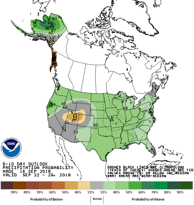
Figures 8 and 9 below show the expected 6-10-day temperature and precipitation outlooks. The colored shading on the map indicates the degree of confidence the forecaster has in the category indicated, where "B" and blue colors indicate "below-normal" and "A" and orange-red colors indicate "above normal". The darker the shading, the greater is the level of confidence. The numbers labeling the contours separating different shades gives the probability that the indicated category (A, B, or N) will occur.
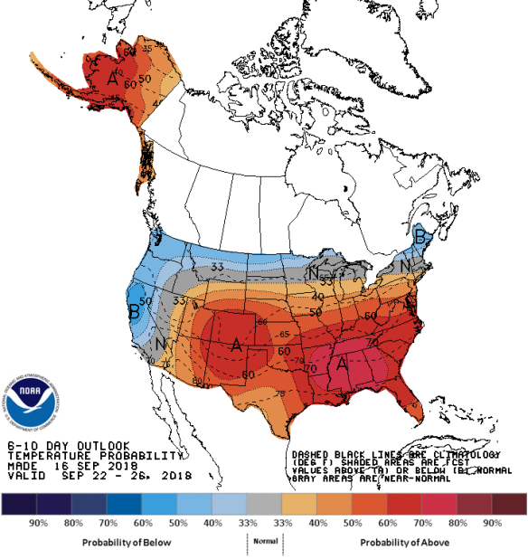
Generally, the probability of below average temperatures (as seen in Figure 8) is moderate over much of Central and Northern California, the Pacific Northwest, northern Idaho, and the northern areas of the Northern Tier States and northern New England. In general, the probability is moderate to high that the rest of the of the country will experience above average temperatures, centered on the Deep South states and Colorado and New Mexico. The chances for above average temperatures is also moderate over almost all of Alaska. Very few locations will experience normal temperatures for this time of the year.
The precipitation outlook for the next 6-10 days (Figure 9) shows the probabilities are low to moderate for below average rainfall over mostly Utah and northwestern Colorado. Low to moderate to high probabilities for above average rainfall exists over much eastern half of the country, the Northern Tier states, the Pacific Northwest and Central and Northern California. Probabilities are high for above average rainfall over much of Alaska, except the southern areas. All remaining areas should experience average rainfall for this time of the year.
Weekly hazards output by the NWS’s Climate prediction center for the next 3-7 days is shown in Figure 10 below.
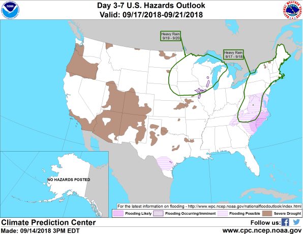
Figure 10 shows that most of the expected weather hazards over the United States in the next 3 to 7 days. Heavy rain should be expected over much of the northern parts of North Carolina, stretching northeastwards into Virginia and all of New England between the 17th and 18th September as the remnants of Florence makes its way towards the northeast. Much of South and North Carolina, Virginia and Maryland will also experience ongoing flooding as rivers crest in the coming days. Heavy rain is also expected over much of the western areas of the Midwest and eastern parts of the Northern Plains states between the 19th and 20th September. There is also a chance of possible flooding over far southwestern Texas during the period as a result of a surge of tropical moisture this past week.
Want to know precisely who NOT to contact during a disaster?
Find out with a free trial