Severe Spring Weather Explained
ContactRelief meteorologist Dr. Kevin Levey explains severe spring weather.
Tuesday, 21 May 2019 10:25:00 -05:00
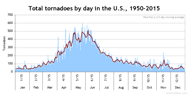
Now is a good time to remind everyone now that spring is well underway, we are well into our annual “severe weather” season over much of the central and eastern parts of the United States. I thought I’d devote this month to remind you all of all aspects relating to spring severe weather in the United States, including thunderstorms, lightning, hail and of course, tornadoes! Figure 1 below shows the total tornadoes by day between 1950 and 2015, with May 25th as the most active tornado day on average in the United states.
When Weather Kills
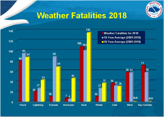
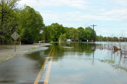
Let’s look at weather fatalities from 2018. Figure 2 below shows that most people succumbed from weather events that involved flooding, followed by heat and the ocean rip-currents. This varies from year to year, but if you look carefully at Figure 2, you will see that on average (30-year average spanning 1989-2018) 136 people die every year in the USA from heat related weather events, however, a combined total of 199 people lose their lives every year from flooding (87), lightning (43) and tornadoes (69). Fatalities from flooding include those from severe weather, thunderstorms, snow-melt river flooding and hurricane storm-surge and excessive rainfall. So, even though heat is the silent (passive) killer in the US, deaths from severe weather such as hail, lightning, tornadoes and flooding definitely are the “active” weather killers out there.
For further statistics for individual years, click here:
http://www.nws.noaa.gov/om/hazstats.shtml
Weather Hazards From Thunderstorms
Thunderstorms are not rare with over 40,000 of them each and every day around the world. Almost every place on the planet has the potential of experiencing a thunderstorm. The most common weather hazards associated with thunderstorms include:
• Lightning
• Flash Floods
• Hail
• Winds (Downbursts, Microbursts)
• Tornadoes
• Hurricanes
Thunderstorms generally form when warm, humid air rises into an unstable atmosphere. Triggers that initiate uplift include heating of the land surface, frontal lifting (cold fronts cause colder, more dense air to move in under warmer, less dense air and hence cause vigorous uplift in the spring) and also terrain – air being forced up mountain slopes causing mountain thunderstorms which are frequent in the Lake Tahoe area in summer and the Rockies in spring and summer. Another ingredient that enhances strong thunderstorm development is for strong divergent (opposite of convergent, i.e. coming together) winds in the upper levels of the atmosphere. Divergent winds actively “suck” up air form the surface, hence aiding strong vertical uplift within thunderstorms.
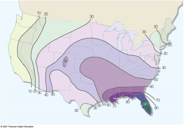
Where do most thunderstorm occur in the United States? Figure 3 below shows the average number of thunderstorms per year in the United States.
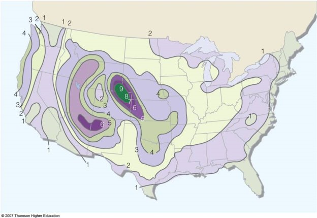
Hail frequency does not follow the same spatial distribution as shown in Figure 4 below.
How Thunderstorms Form
There are essentially three basic thunderstorm types:
• Air-Mass Thunderstorms
• Multi-Cell Thunderstorms
• Supercell thunderstorms
Most thunderstorms form with three stages: the cumulus stage (also known as the developing stage) when storm clouds form, the mature stage when the storm is fully formed, and then the dissipating stage when the storm weakens and breaks apart. Figure 5 below shows the three stages.
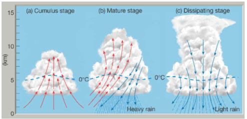
The Cumulus Stage
When warm, moist air moves upward in an updraft, cumulus clouds will form in the atmosphere. The moisture in the air condenses into water droplets as it rises and cools. The cloud will continue to grow as long as warm air from below continues to rise (updrafts). There are several ways that an updraft of warm moist air can form. Sometimes air is forced up the side of a mountain. Air is also forced upward at weather fronts, where warm and cool air masses collide. However, most often than not, updrafts form without a mountain or front to guide them – they form since warm air always rises. Air near the ground heats up during the day as energy from the Sun heats the ground, which then heats the air. The warm air rises higher in the atmosphere since warm air is less dense (lighter) than cool air (which is more dense and heavier). The cloud also extends above the freezing level (0?C/32?F) in the atmosphere.
The Mature Stage
As the cumulus cloud continues to grow, the tiny water droplets within it grow larger too as more water from the rising air is added to the droplets. The cloud starts to look dark and grey as more water is added to it. The droplets that make up the cloud become heavy as they continue to grow. Raindrops start to fall through the cloud when the rising air can no longer hold them up and gravity pulls the raindrops back to the ground. In the general area where raindrops that are falling out of the cloud, is cool dry air that also flows downward in the cloud. This air that is cooler and moving towards the ground is called a downdraft and also aids in pulling the raindrops downward. With an updraft, downdraft and rain, the cloud is now called a cumulonimbus cloud and the cycling of air up and down is called a thunderstorm cell.
The Dissipating Stage
When the downdrafts in the cloud become stronger than the updraft, the storm starts to weaken. Since warm moist air can no longer rise, cloud droplets can no longer form. The storm dies out with light rain as the cloud disappears from bottom to top. The whole process takes about one hour for an ordinary thunderstorm. Severe thunderstorms like supercells and squall lines are much larger, more powerful, and last for several hour
Air Mass Thunderstorms.
Air Mass thunderstorms are the most common and least destructive. Their lifespans are generally less than an hour and are very localized. They are also called ordinary, single-cell or garden variety and are not severe in nature, i.e. generally only producing rainfall. They are very common in the spring and summer over much of the central and eastern United States.
Multi-Cell Thunderstorms
A multi-cell storm is a common, garden-variety thunderstorm in which new updrafts form along the leading edge of rain-cooled air (the gust front). Individual cells usually last 30 to 60 minutes, while the system as a whole may last for many hours. Multicell storms may produce hail, strong winds, brief tornadoes, and/or flooding as shown in Figure 7 below.
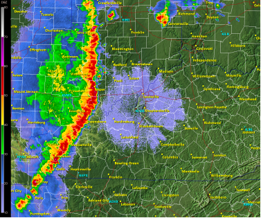
A squall line is a group of storms arranged in a line, often accompanied by “squalls” of high wind and heavy rain. Squall lines tend to pass quickly and are less prone to produce tornadoes than are supercells. They can be hundreds of miles long but are typically only 10 or 20 miles wide. Figure 8 below shows a typical squall line depicted on radar by the bright reds and oranges.
Supercell Thunderstorms
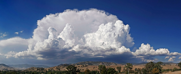
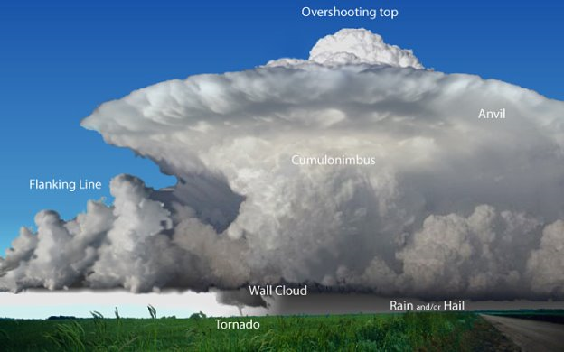
A supercell is a the most severe of all thunderstorms and generally last longer than 1 hour. The supercell thunderstorm is a highly organized storm consisting of an updraft (a rising current of air) that is tilted and rotating and a downdraft. This rotating updraft - as large as 10 miles in diameter and up to 50,000 feet tall - can be present as much as 20 to 60 minutes before a tornado forms. This rotation is called a mesocyclone when it is detected by Doppler radar. The tornado is a very small extension of this larger rotation. Most large and violent tornadoes come from supercells. Heavy rainfall and often hail falls to earth in the strong downdrafts which can also be very dangerous to aircraft. Very severe downdrafts are known as microbursts. Figure 9 below shows the typical features of a supercell thunderstorm.
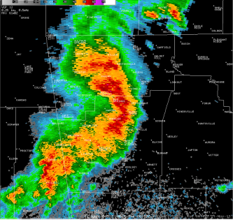
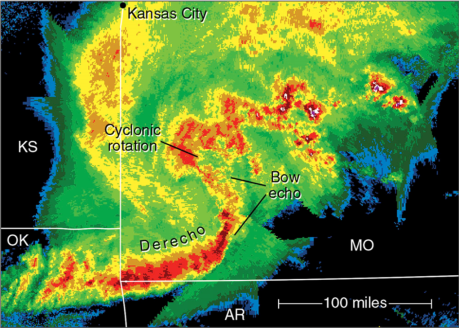
A bow echo is a radar signature of a special kind of squall line that “bows out” as winds blow from behind the line and circulations develop on either end. Figure 10 below shows a typical bow echo on radar. A strongly bowed echo may indicate high winds in the middle of the line, where the storms are moving forward most quickly. Brief tornadoes may occur on the leading edge of a bow echo. Often the north side of a bow echo becomes dominant over time, gradually evolving into a comma-shaped storm complex.
A Mesoscale Convective System (MCS) is a collection of thunderstorms that act as a single system. An MCS can spread across an entire state and last more than 12 hours. On radar one of these large weather phenomena might appear as a solid line, a broken line, or a cluster of cells. This all-encompassing term can include any of the following storm types:
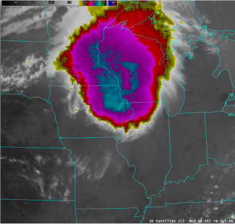
Mesoscale convective complex (MCC)—A particular type of MCS, a MCC is a large, circular, long-lived cluster of showers and thunderstorms identified by satellite. It often emerges out of other storm types during the late-night and early-morning hours. MCCs can cover an entire state as shown in Figure 11 below.
Mesoscale convective vortex (MCV)—A low-pressure center within a MCS that pulls winds into a circling pattern, or vortex. With a core only 30 to 60 miles wide and 1 to 3 miles deep, a MCV is often overlooked in standard weather analyses. But an MCV can take on a life of its own, persisting for up to 12 hours after its parent MCS has dissipated. This orphaned MCV will sometimes then become the seed of the next thunderstorm outbreak. An MCV that moves into tropical waters, such as the Gulf of Mexico, can serve as the nucleus for a tropical storm or hurricane.
A derecho is a widespread, long-lived wind storm that is associated with a band of rapidly moving showers or thunderstorms. Although a derecho can produce destruction similar to that of tornadoes, the damage typically is directed in one direction along a relatively straight path. As a result, the term “straight-line wind damage” sometimes is used to describe derecho damage. By definition, if the wind damage swath extends more than 240 miles and includes wind gusts of at least 58 mph or greater along most of its length, then the event may be classified as a derecho. Bow echoes discussed earlier can also be part of these derechos as shown in Figure 12 below:
Next week we will look at supercells and tornado formation in much more detail.
Want to know precisely who NOT to contact during a disaster?
Find out with a free trial